
Baton Rouge ZIP Coverage List
City-Parish Open Data supplies the clearest official list of physical-address ZIP values whose city field reads BATON ROUGE. The dataset was inspected on August 25, 2026. It is evidence of address records, not a list of post-office stations, and it does not promise that every special or box-only code appears.
| ZIP | Area in official data | Postal service note | Search caution |
|---|---|---|---|
| 70801-70803 | Downtown, central, and a small campus or institutional set | 70801 and 70802 share a DMM destination group | Verify a campus or special-use address with USPS |
| 70805-70807 | North city, Goodwood-central, and Scotlandville-area records | 70806 includes the Goodwood library sample | Neighborhood labels are descriptive, not postal borders |
| 70808-70810 | South-central, southeast, LSU-to-Bluebonnet records | DMM groups do not equal street-delivery boundaries | Check each exact address |
| 70811-70817 | North edge, east, southeast, and small institutional sets | Several codes route through nearby label groups | Municipality may differ from postal city |
| 70819-70820 | East and LSU/south physical records | Grouped with other Baton Rouge destinations | Use GIS for parcel and jurisdiction context |
| 70836 | Institutional and south-area physical records | Grouped to a Baton Rouge service destination | Do not infer a resident from the code alone |
The physical list contains 19 distinct values: 70801, 70802, 70803, 70805 through 70817 except 70804, plus 70819, 70820, and 70836. A ZIP directory should show the source date because postal and GIS data can change.
Downtown Baton Rouge ZIP Records
Downtown codes illustrate why a short neighborhood label is not enough. EBRGIS identifies 222 Saint Louis Street as 70802, with Beauregard Town, Old Town, OLD SOUTH BATON ROUGE, voting precinct 1-001, and Council District 10 among its civic fields. Those layers describe one address from several official systems.
ZIPs 70801 and 70802 are tied together in USPS DMM label material, while 70803 appears as a small campus or institutional physical set in EBRGIS. None of that proves who occupies a place. The code narrows geography; the parcel, directory, court, or voter source answers a different question.
Baton Rouge Special-Use ZIP Candidates
USPS Domestic Mail Manual label lists associate more codes with Baton Rouge service destinations than the City-Parish physical-address dataset returns. These are verification candidates. They should not be described as ordinary residential areas without a current address-level USPS result.
| ZIP group | Official association | How to treat it |
|---|---|---|
| 70821-70823, 70825 | Baton Rouge label groups | Possible box, special, or institutional use; verify exact address |
| 70827, 70831, 70833 | Grouped with Baton Rouge destinations | Not found in the city physical set |
| 70835, 70837, 70874 | Appears in USPS label-list material | Current street coverage was not established |
| 70879, 70883, 70884 | Postal label association | Check current status in USPS lookup |
| 70892-70896, 70898 | Government, institutional, box-style, or other special candidates | Do not assign a neighborhood without address proof |
The official USPS ZIP Lookup offers address-to-ZIP, city-and-state-to-ZIPs, and ZIP-to-cities modes. A result standardizes mail routing. USPS warns that it does not confirm a person or business at the address.
Find Baton Rouge Residents by ZIP
A ZIP can trim a long name search, but no inspected official tool provides one open roster of everyone in that area. Use the code as a filter or a returned field, and then confirm the name or address through the correct custodian.
- Standardize the full address with USPS. Save the postal city and ZIP without treating either as municipal proof.
- Run the address in EBRGIS Property Lookup. Record the lot ID, normalized address, ZIP, subdivision, and jurisdiction fields.
- Use an official name form that accepts ZIP only when the lawful purpose and search terms fit. Treat the match as a lead.
- Check the Assessor for the tax parcel and the Clerk for a legal deed when ownership matters. Do not substitute GIS detail for either record.
- Once the area narrows to one road, use the Baton Rouge street directory for address-level work.
The Louisiana Treasury unclaimed-property search accepts a name or business name with city and ZIP. A match points to a financial asset, not current residence. The public EBRGIS search form has address, subdivision, business, NAICS, and lot-ID modes but no direct ZIP box; ZIP appears in its results and data fields.
Baton Rouge ZIP Voter Fields
The Louisiana Secretary of State Voter Portal has both name-based and address-based routes. The address form shown by the official portal requests a ZIP, street address, apartment or lot when needed, and city. It finds voters associated with one address. It is not a free ZIP-wide resident list, and voter information remains subject to Louisiana restrictions and protected-address rules.
| Field | Input | Role in the search |
|---|---|---|
| ZIP Code | Postal code | Narrows and validates the address form |
| Address | Street address | Identifies the residence point being checked |
| Apt/Lot | Unit or lot detail | Separates units when applicable |
| City | Postal city | Completes the address entry |
The official voter address form shows how ZIP is used alongside the rest of the address.
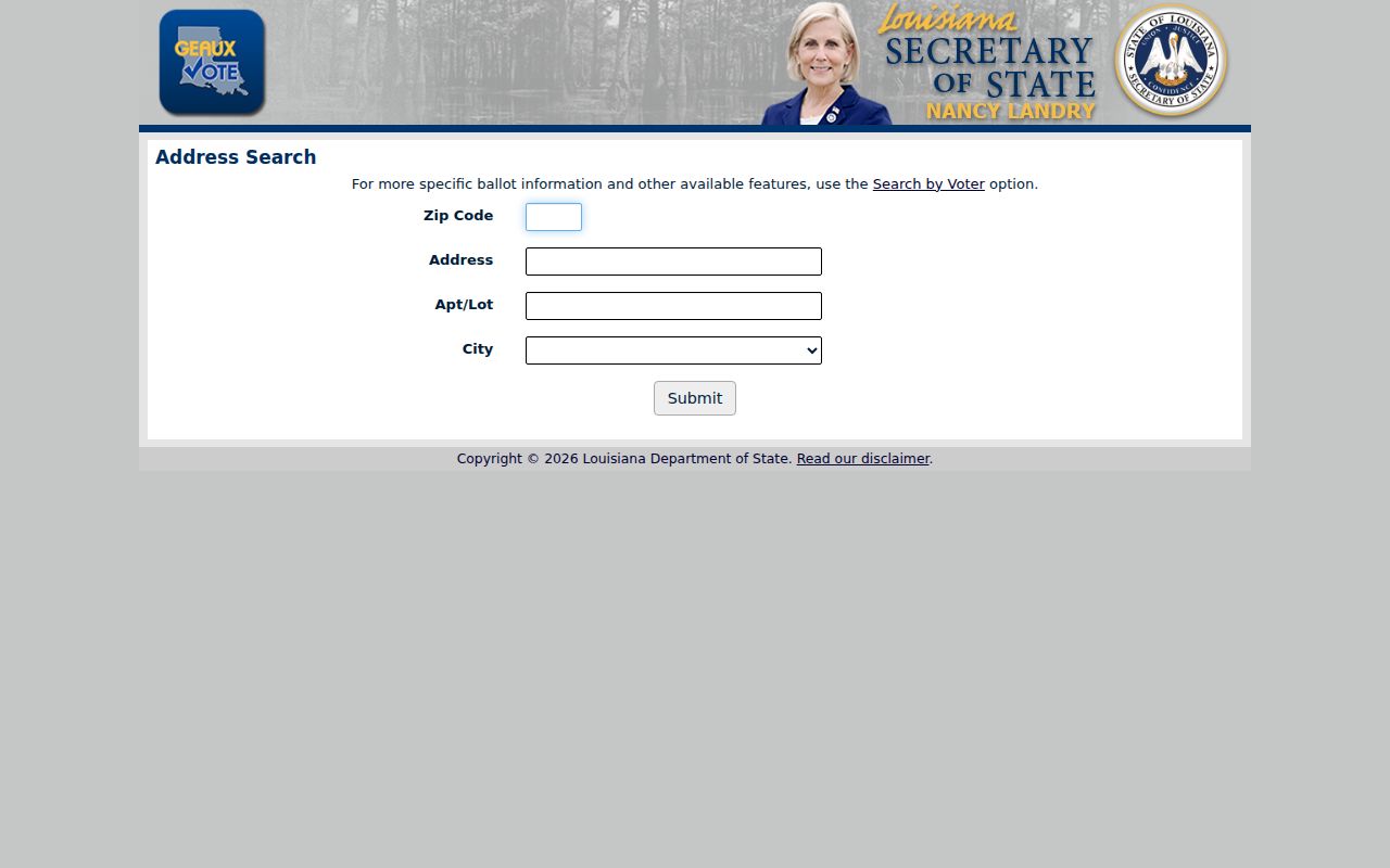
The captured form supports an address check, not a claim that all people within one Baton Rouge ZIP can be browsed.
Baton Rouge ZIPs Versus City Limits
East Baton Rouge Parish includes Baton Rouge, Baker, Central, Zachary, and unincorporated areas. Postal labels cross those civic lines. The sharpest example is 70818: USPS label material groups it with Baton Rouge service destinations, while EBRGIS returns physical records with city CENTRAL. A Baton Rouge mailing label therefore cannot settle city jurisdiction.
Use the EBRGIS jurisdiction lookup with the address number and street name. Its result classifies the address by municipality or unincorporated status. The annexation layer then adds time: it maps city expansion from 1817 and individual annexations since 1949. Annexation can change jurisdiction while the ZIP stays the same.
- ZIP and ZIP+4
- The five-digit delivery area and a more precise four-digit add-on for a delivery segment.
- PO-box ZIP
- A code used chiefly or only for post-office boxes rather than ordinary street delivery.
- Unique ZIP
- A code assigned to one large organization or institution.
- Carrier route
- A postal delivery route inside a ZIP, not a city or neighborhood border.
Baton Rouge ZIP Address Keys
A parcel can have several address forms. The situs address is the physical location. The tax mailing address is where assessment mail goes. A legal description identifies land through lot, block, subdivision, or survey terms. USPS supplies a standardized mailing form. None should be silently replaced by another.
EBRGIS adds a 9- or 10-digit lot ID, address-point and address identifiers, street parts, subdivision, business details, planning areas, census fields, and government districts. A lot ID is a GIS key, not a Clerk recording number. When a search returns more than one address point, save each candidate before deciding which parcel fits.
The current dataset draws address information from subdivision plats, building permits, the E-911 Master Street Address Guide, the Polk City Directory, and field collection. That mix makes it valuable for normalization, while legal ownership still belongs with the Assessor and Clerk records.
Older Baton Rouge ZIP Addresses
Modern ZIP-based searches can fail on old street names. The City-Parish street-change file includes dated 1942 changes, such as Fourth Street to North 31st, Gladiola Circle or Road to Aster Circle or Road, and Gordon Avenue to Ross Avenue. Search both names along with subdivision, cross street, and lot or block.
The current street list is marked as updated weekly. EBRGIS search tips use 1ST, 2ND, and 43RD for numbered streets and retain SAINT in names such as SAINT LOUIS. Prefixes and suffixes are optional, and the search supports wildcards. Normalize the current form before using USPS, then keep the historic form for directory, deed, and newspaper work.
Confirm a Baton Rouge ZIP Result
One successful postal match is not enough to identify a person or establish a municipal boundary. Each official source has a narrow role. A returned code can be stale, tied to a mailing address, or shared across civic jurisdictions. Note the date of each lookup and preserve the exact form of the address that produced it.
- USPS confirms the standardized mailing form and current postal association.
- EBRGIS returns the physical-address ZIP, lot key, subdivision, and civic geography.
- The jurisdiction lookup separates Baton Rouge from Baker, Central, Zachary, or unincorporated parish land.
- The Assessor provides the tax parcel route, subject to the live portal's available fields.
- The Clerk's deed and mortgage records establish recorded land transactions.
Use the Baton Rouge ZIP directory to narrow geography, not to label a household. Protected addresses and voter-use limits still apply. Records may lag a move, and a mailing address can belong to a person, business, institution, or box service. Verify any important conclusion with the office that keeps the source record.
For a disputed address, save three official outputs: the USPS standardized form, the EBRGIS property detail, and the jurisdiction result. Compare the city field, ZIP, street spelling, lot ID, and municipality. If the goal concerns recorded ownership, add the Assessor parcel card and Clerk instrument. If the address is historic, add the former street name and annexation date. This layered check is especially important near Central and other parish boundaries, where a Baton Rouge postal association may coexist with a different municipal jurisdiction. It also prevents a neighborhood name or mailing label from being treated as a legal boundary.